

In the Italian landscape, there is a silent border advancing: agricultural and natural surfaces becoming roads, warehouses, yards, plots. It is not a destiny, it is a choice. And like every choice, it can be measured, understood, transformed.
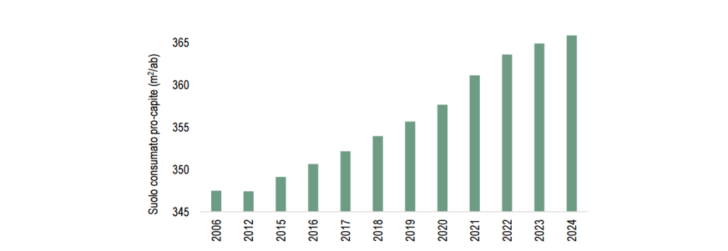
The 2025 edition of the report “Land consumption, territorial dynamics and ecosystem services” curated by ISPRA and SNPA gives us a clear picture: in a single year, 2024, 83.7 km² of land were transformed, equal to 2.7 m² per second, with a net consumption reaching 78.5 km², the highest value in the last twelve years. Artificial coverings now occupy over 21,500 km² of the country, 7.17% of the national territory, against a European average of 4.4%.
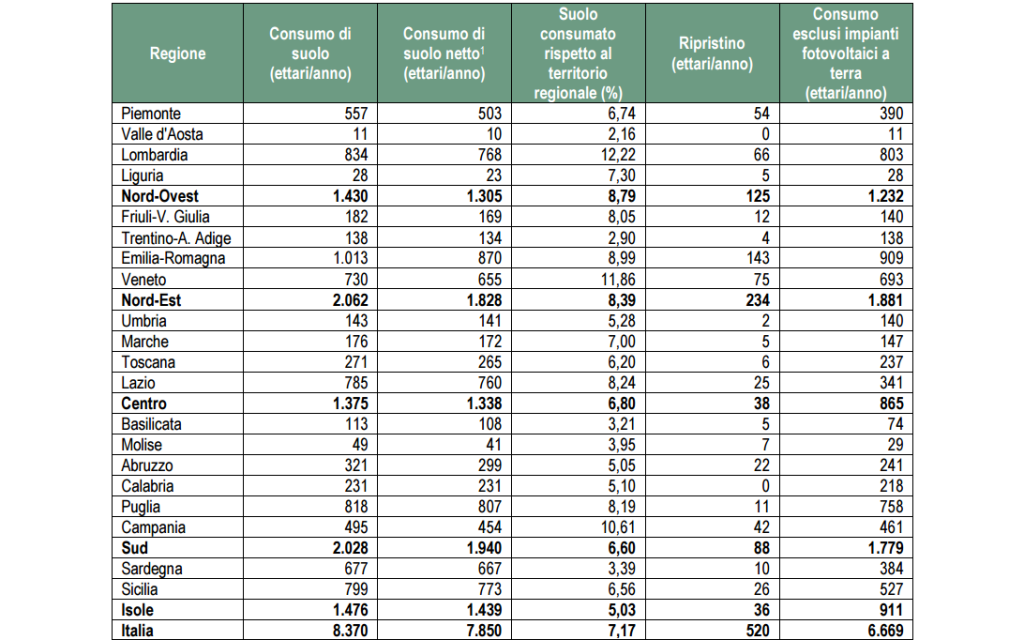
The pressure is not uniform. Lombardy (12.22% of land already consumed), Veneto (11.86%) and Campania (10.61%) stand out. In 2024, the greatest increases were recorded in Emilia-Romagna (+1,013 ha), Lombardy (+834 ha), Apulia (+818 ha), Sicily (+799 ha) and Lazio (+785 ha). At the municipal level, new peaks in Tarquinia, Uta and Montalto di Castro.
“Pure” impermeabilisation weighs heavily: +24.5 km² between new permanent consumption and surfaces that passed from reversible to permanent.
This is the most critical form of soil transformation, where the land is sealed by materials like asphalt or concrete and loses its ability to absorb water, breathe and regenerate.
Unlike temporary or reversible coverings, pure impermeabilisation permanently compromises the ecological functions of the soil (filtration, aquifer recharge, microclimate regulation and biological fertility), making any form of future restoration difficult.
Construction sites are growing (about 4,678 ha, 56% of annual consumption), logistics hubs in the North, ground-mounted photovoltaic plants (+1,702 ha in 2024), and, more recently, land occupation linked to data centers (>37 ha in 2024 alone), phenomena that are reshaping urban edges and agricultural plains.
The consequences are concrete: more fragmentation of the landscape, urban heat islands with differences that can exceed 10°C between cities and rural areas, loss of ecosystem services with “hidden costs” estimated between 8.66 and 10.59 billion euros per year for cumulative impacts from 2006–2024.
On the policy front, the report fits into the evolution of the European framework: Nature Restoration Regulation in force since August 2024, a new directive on soil monitoring and resilience being adopted, and the reiterated request for a national law on land consumption aligned with EU objectives of No Net Land Take.
Data that speaks to practice: the thread with our work
Se il rapporto misura ciò che accade, il nostro lavoro racconta cosa si può fare. Da anni, in Rural Hack, intrecciamo la ricerca con la pratica, trasformando l’innovazione in esperienza concreta sul territorio. La If the report measures what is happening, our work tells what can be done. For years, in Rural Hack, we have been intertwining research with practice, transforming innovation into concrete experience on the territory. Water and fertility management with Keyline Design, good practices of regenerative agriculture, attention to soil biodiversity, and a civic analysis of the impacts of soil pollution on the SDGs. The compass is always the same: shifting the centre of gravity from mere building expansion to the living maintenance of agro-ecological systems.
- With Keyline Design we have shown how the design of water lines reduces runoff, erosion and water stress, increasing infiltration and the resilience of the productive landscape.
- With regenerative agriculture we have documented practices that restore organic carbon, structure and life to the soil, transforming fields into widespread climate infrastructures.
- With our focus on soil and SDGs we have linked soil health to food security, water, climate, biodiversity, highlighting the urgency of territorial plans that limit impermeabilisation and promote restoration.
The 2025 report confirms, in numbers, what we have anticipated in vision in our articles: cities and peri-urban fringes are the hot front of transformation, logistics drives land demand in accessible areas, and without significant restoration, the goal of zero net consumption remains distant.
The school on soil: learning that becomes territory
Our Seasonal School FoodSystem 5.0 was born also for this: to transform data into skills and skills into territorial actions. Students, farmers, technicians and administrators work on real cases: water mapping, keyline design, regeneration plans at company and landscape scale, monitoring metrics. It is a training ground for the future, where theory meets doing: from the drone that reads water stress, to the mapping of ditches and terraces, up to de-impermeabilisation measures in urban contexts.
This continuous dialogue between measurement (report) and care (practices) is the heart of our strategy: Italy does not only need to stop the loss, but to shape landscapes that work as ecosystems.
Lines of work: from report to roadmap
- Reduce land demand: urban regeneration, reuse of disused areas, densification with structural greenery and nature-based solutions, urban plans that limit consumption in areas at hydraulic and landslide risk.
- Restore: removal of impermeable surfaces where possible, urban ecological wedges, blue and green corridors, urban forestry to cool heat islands.
- Design water: Keyline Design, check dams and micro-reservoirs, management of embankments and dry-stone walls as widespread infrastructures for hydro-geomorphological resilience and biodiversity.
- Measure to decide: use SNPA/ISPRA datasets and cartographies as baselines for territorial plans and calls, with KPIs on soil, climate, ecosystem services and avoided costs.
- Skills and supply chains: train technicians, businesses and public administrations, creating school-construction sites and local networks able to move from pilot projects to programmes.
Conclusion
The 2025 report tells us that the red line is advancing, but also indicates where and how to intervene. If we look at the soil as natural capital and living infrastructure, every planning choice becomes a choice of collective well-being and safety. Stop impermeabilisation where it is not needed, restore where possible, design water and regenerate productive systems: this is the trajectory.
Download the full report, read the data of your territory, bring them into your plan, your business, your classroom.